|
Prosurv Pocket Quads.NET™
(includes Prosurv Imaging)
Get Pocket Quads AND Imaging for $199.00!
Download the ALL NEW Pocket Quads.NET!
7.5' USGS Topo Quad Sheet Software for your
Pocket PC
Version 1.3 Now Available!
New in Version 1.3
-
ZOOM IN/OUT IN REAL-TIME! Select a pre-defined zoom or enter your own.
Auto-determines lowest zoom (ie 35%). Creation and plotting of points
(annotations) plots at any zoom. Imported points, point, and line regen
automatically scaled to fit zoom. All screen taps are scaled to locate
points correctly, give correct distances etc...
-
Export data for import as All Topo Maps
annotation data (lat/long). Exports a text file for copy/paste import into
the All Topo Maps program (not included) Annotations file, which then
plots the data on the current map on your PC.
-
New Tap Data function lets you tap anywhere on the screen and view that
position's Lat/Long and Northing/Easting.
-
New Midpoint creation routine. Select the
Midpoint function (a checkmark will appear next to it), then tap two
existing points on the screen. A midpoint is computed and displayed. You
can navigate to the new midpoint just like any other point. The new
midpoint is treated as an Imported Point.
-
New minimize screen when navigating to a point. Just tap the Minimize
button and the new small screen will appear. The screen displays a large
blue arrow and N/E or Bg/Distance information along with showing the point
# (name) being navigated to. This small-footprint screen allows viewing of
the Quad while staking (navigating) to the point. The display can be moved
by dragging the box.
-
Panning can be accomplished, as before, by
holding down the 4 direction keys on the hardware device, or by dragging
the screen (touch the stylus to the screen and drag it around--the image
will follow your stylus). In version 1.3, if the Overview grid is not
being displayed, then dragging to the edges of the current slice will
produce a 'beep' sound when you reach the edge. IF THE OVERVIEW GRID IS
BEING DISPLAYED, THEN PANNING TO THE EDGE OF THE SLICE WILL AUTOMATICALLY
LOAD THE NEXT SLICE, UP, DOWN, LEFT, OR RIGHT.
-
Several bug fixes and minor enhancements have also been made.
-
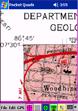
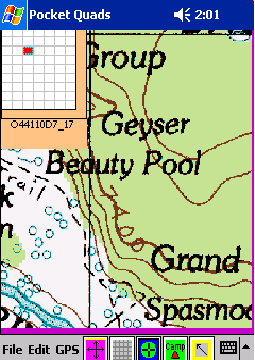
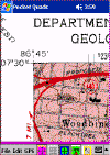
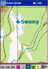
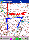
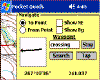
View Full-size 7.5' USGS Topo Quad Sheets
on your Pocket PC!
-
GREAT FOR VACATIONS! IMAGINE HAVING ALL OF THE TOPO
QUAD SHEETS FOR AN ENTIRE NATIONAL PARK ON YOUR POCKET PC!
YELLOWSTONE NATIONAL PARK CONSISTS OF ABOUT 70 QUAD SHEETS, WHICH CAN
EASILY FIT ON A 256MB FLASH CARD! OR, IF YOU'RE GOING TO THE GRAND
CANYON, JUST PREPARE YOUR QUADS BEFORE YOU GO, LOAD THEM ONTO A FLASH
CARD, AND YOU'LL HAVE ALL THE QUADS YOU NEED FOR CANOEING, HIKING, AND
CAMPING IN THE WILDERNESS!
-
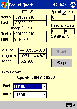
Connect to your GPS receiver for
Real-time viewing of your location on the Quad
-
Automatically switches between Quads as
you walk or drive, based on the current GPS position
-
Real-time Pan
-
Store up to 170 compressed quads on a
512MB RAM CF or SD Card (Card not included) using Prosurv Imaging to
prepare the Quads you need
-
Prosurv Imaging prepares your Quads by
slicing it into columns and rows. Pocket Quads automatically
selects the correct slice to display based on your current GPS position
-
View and switch between individual slices
by tapping the Grid
-
Automatic Centering on GPS
-
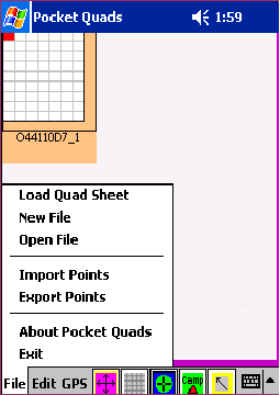
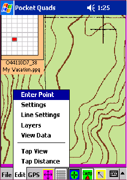
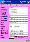
Create Files to store GPS points, text,
and lines
-
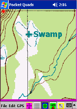
Create Text and Lines on the Quad, which
are stored in your File and re-drawn automatically
-
Import .asc points files that contain a
point name, northing, easting, elevations, and feature code
(description)
-
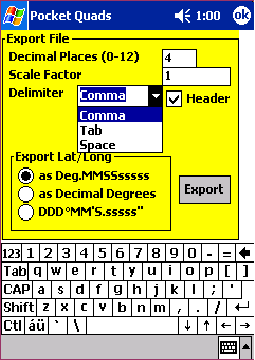
Export collected data as a comma, tab, or
space delimited text file
-
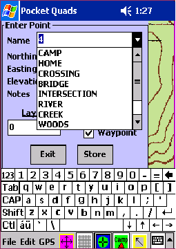
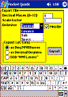
Hand-enter points as northings and
eastings, or latitude/longitude
-
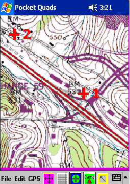
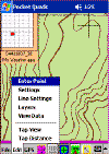
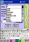
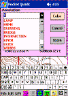
Tap and Create Annotations (points)
-
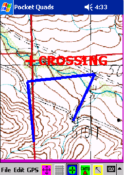
Draw Lines
-
Assign points and lines to layers
-
Turn Layers On/Off
-
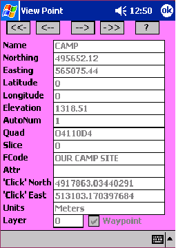
View Data record by record
-
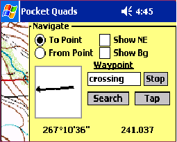
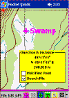
Tap to View a Point
-
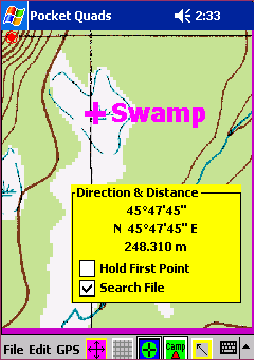
Tap for Distances between screen
locations (such as from a road intersection to a bridge), or from point
to point
-
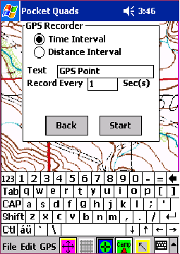
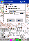
Record GPS Points by Time or Distance
Intervals
-
Navigate to Points (Stakeout)
-
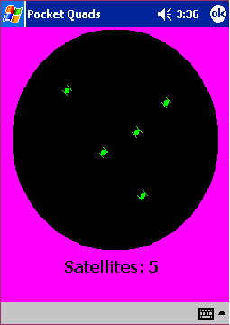
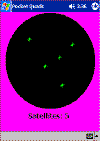
View available Satellites and their
positions
-
Set Text font, size, color, and more
-
Set Line Color and Width
-
Connect GPS Points automatically (draw
lines between them)
-
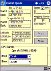
View GPS Data such as current Northing &
Easting, Speed, Heading, and Latitude & Longitude
-
Create your own List of Annotations
(point names) that you can select from using a drop-down list
-
Edit the Defaults.txt file to customize
Pocket Quads
-
Work in any NAD83 State Plane Coordinate
or UTM Zone, even if the Image is using a different zone. For
those familiar with State Plane Coordinates, this lets you work, for
example, in Wyoming West Central coordinates, even though the image is
using UTM 12. For the layman, knowledge of these coordinate
systems is not required, since Pocket Quads will simply work in the zone
that the image is in.
-
For the surveyor, Pocket Quads can be
very helpful and productive in searching for corners, NGS monuments and
much more
Download the Documentation*
-->Download
Pocket Quads.NET!<--
-
View 1:24,000 / 1:100,000 / AND 1:250,000
Scale USGS Maps on your Pocket PC!
-
Real-time GPS tracking on your Quad as
you walk or drive
-
Automatic switching between Quads based
on your GPS location
-
Quads are stored in a compressed
format--fit 170 Quads on a single 512MB RAM CF Card!
-
Prosurv Imaging required (for setting up
the Quads to use on your Pocket PC)
-
Great for Hunting, Camping, Hiking, and
Vacations!
-
"Blue" grid indicates if a quad isn't found
-
Red, Yellow, Green indicate your GPS "fix"
-
Keeps tracking if quad not found, and displays a quad when found
-
Exiting the GPS Data screen (lat/long) in previous versions would stop the
GPS. This has been fixed.
-
New, LARGE EASY TO READ GPS data screen. Go from the normal GPS data
screen to a new, ENLARGED data screen showing the Lat, Long, Northing,
Easting, and Elevation. Includes Red/Yellow/Green GPS fix indicator
"box".
-
Movement-based navigation (stakeout) arrow
shows which direction to go to get to your point, based on your movement
direction.
(GPS Receiver not included)
*Right-click and select Save Target As to
save the documentation to your computer. Documentation is in Adobe
Acrobat .pdf format. The Adobe Acrobat Reader is required to view
the file. Visit www.adobe.com to
download the free reader.
Prosurv Pocket Quads uses
GPSTools from franson.biz
for acquiring GPS Data. |