|
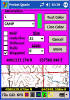
Prosurv Pocket Quads™
Version 1.5 Features |
Included |
|
Uses
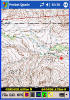
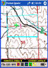
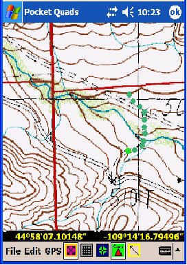
full size Topo maps, processed by Prosurv Imaging including 1:24000
(7.5' Quadrangle), 1:100,000, and 1:250,000 Scale Maps. A lossless
(png) file compression is used, resulting in small file sizes without any
loss of quality. Typical map sizes are 3 to 4MB per Topo Map, once
processed. Easily store 150 to 170 topo maps per 512MB RAM!
For comparison, Yellowstone National Park is made up of about 80 Topo
Maps. |
● |
|
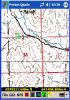
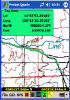
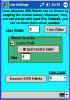
Connects to your GPS receiver for Real-time viewing of your location
on the Quad. Supports
Bluetooth®
GPS Devices, and most any GPS Receiver with NMEA Data Output |
● |
|
Automatically switches between Quads as you walk or drive, based on
the current GPS position |
● |
|
Automatic Centering on GPS - Turn GPS Centering on or off. When
off, Pan around the map by dragging the stylus or holding down the
4 direction key (up/down/left/right) |
● |
|
Allows
you to Load a Quad Sheet Manually - Great when using a "Big Topo Map"
that you created using All Topo Maps software |
● |
|
Feature Name Searches - Supports the USGS's GNIS Databases!
Search for a place, such as Old Faithful from thousands of records.
Finds all matching records. Select the one you want and tap the Load
button to load the Quad sheet that contains that feature automatically!
The feature is automatically centered on the screen. |
● |
|
Radial
Feature Name Searches - Search for Features by Radius from a screen
tap or your GPS position. Just select a Designation (Feature Type)
from the drop-down list, such as Airport, School, Stream, Lake, Tower,
Summit etc... Then enter a radius such as 10 miles (supports miles,
feet, km's, meters). Pocket Quads will search for all matching
features within that radius. Select the closest or view them all.
Step through each matching record, one by one, to find the one you want.
Then tap the Load button to automatically load the Quad sheet and display
the feature! |
● |
|
Import New Features -
Allows you to add new features from a text file, expanding your database |
● |
|
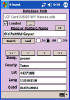
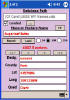
Create Job Files to store
your GPS Points |
● |
|
Open a Previous Job File |
● |
|
Import
Points - Allows you to import point lists into your current job file.
Format is Point#,Northing,Easting,Elevation,Description |
● |
|
Plot
Imported Points - Automatically plots your imported points on the
screen, when the Quad containing that point is displayed |
● |
|
Export
All Data - Export all your Pocket Quads Data, over a dozen fields
(columns) of data per point. View in Notepad or Excel and bring data
in to virtually any other software |
● |
|
Export
For All Topo Maps - Output is a simple Lat,Long text file for
easy copy/paste into All Topo Maps Annotations |
● |
|
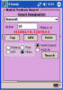
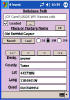
Enter
Points - Add new points to your job file by Northing and Easting or
Latitude/Longitude. Enter Lat/Long in Decimal or DMS format.
Displays entered points on the topo map automatically |
● |
|
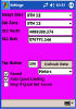
Settings - Image Zone is set automatically (such as UTM12), or select
the image zone manually. Your job zone can be different from the
image zone, such as Wyoming West Central. All zones are NAD83 in
Pocket Quads.NET (Prosurv Imaging allows NAD27 and automatically converts
maps to NAD83 when processing for Pocket Quads.NET). Select Meters,
US Foot, or International Foot units. Turn Sound on/off.
Select whether to automatically load quad sheets based on GPS position (on
by default). |
● |
|
Line Settings - Set
the Line Color and Layer. Set the Bread Crumb color and size. |
● |
|
Layers - Turn layers
on/off |
● |
|
View Data - View
waypoints, imported points, GPS points and much more, record by record |
● |
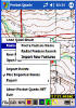
Tap Functions -
- Tap to View points
- tap a point on the screen to view it's data
- Tap Distance -
tap two locations on the screen to see a distance between them.
Finds points automatically within a certain area of the tapped location
- Tap Data -
Lat/Long and Coordinates are displayed as you tap around the screen
|
● |
Select a Scale -
While receiving GPS Data, automatically searches for the correct topo map
in that scale. If found, displays the map automatically.
- 1:24,000 Scale
- 1:100,000 Scale
- 1:250,000 Scale
|
● |
Zoom - Real-time
zooming while connected to your GPS receiver. Automatically
re-centers if receiving GPS Data. All points are resized and
re-positioned automatically on the screen. Coordinates of screen
taps correctly adjust for the zoom amount. Pre-set zooms are:
- User - Set the zoom to
whatever you'd like it to be, down (down to the "lowest zoom") or up
- Lowest Zoom - Computes
the lowest zoom possible for that map, typically about 39%
- 50%
- 75%
- 100%
- 150%
- 200%
- 300%
|
● |
|
Start GPS - Just tap
this menu item to start the GPS connection. Everything else is
automatic, including loading the correct topo map, and centering on your
GPS position. Automatically searches for the correct com port and
baud settings, including Bluetooth, if used. Activates the GPS
receiver to begin acquiring satellites. |
● |
|
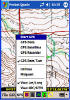
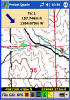
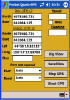
GPS Data - View GPS
Data, such as Lat/Long, Elevation, UTM or State Plane coordinates, speed
of travel, direction of travel and more |
● |
|
GPS Satellites -
Graphical view of the current positions of acquired satellites |
● |
|
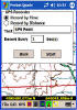
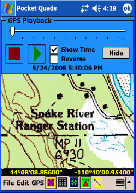
GPS Recorder - Turn
GPS recording of points on or off. Select to record by time or
distance intervals, such as every second, or every 50 feet. |
● |
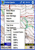
Utilities -
- Convert between
Lat/Long and State Plane or UTM Coordinates
- Clear the Job Registry
- start with a new job file the next time you run Pocket Quads.NET
- Load Defaults.txt -
Re-load the defaults.txt file
- Quad Path - Set the
path to your topo maps quickly and easily, such as \CF Card\Quads\ or
\SD Card\Quads\
|
● |
|
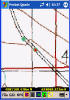
Midpoint - Create a
midpoint between two tapped points. Great for surveyors trying to
find 1/4 section corners |
● |
|
View your current GPS
position on-screen in real-time - Select between displaying Lat/Long
or UTM/State Plane Coordinates |
● |
|
Create Annotations
(Points) by Tapping the Screen - Stores both the tapped location
and the current GPS position when you tapped in the same record.
Point is displayed automatically. Select Font Size, Style, Layer and
more. When it's time to Navigate (Stake) to the point, you can
select to navigate to the GPS position or the Tapped Location! |
● |
|
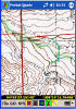
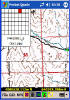
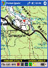
View the Overview Grid -
Processed Topo Maps are cut into slices. One quad sheet may
contain as many as 63 slices (tiles) or more. This grid allows you
to see which slice you're currently in, and allows you to switch to any
other slice just by tapping the grid. |
● |
|
Draw Lines - The
"camp" button allows you to draw lines on the screen instead of creating
points. Tap the screen twice to create the first line, then each tap
continues the polygon. Lines are stored with your job file, so they
re-appear when you use the same job again. |
● |
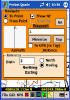
Navigate (Stake) to
Points - Features include:
- Show North/East to the
point
- Show Azimuth/Bearing
with Distance to the point
- Show information as
'To the Point' or 'From the Point'
- Select a point for
navigating by tapping on-screen, or just enter the point
- Navigate to the GPS
position of a point (ie the GPS position when the tapped point was
created), or navigate to the tapped location of the point
- Navigate to Imported
Points
- Arrow reference based
on North or Movement. If based on movement, heading towards the
point will show an arrow straight ahead, while heading away from the
point will show an arrow pointing down
- Minimize the Navigate
screen so you can see the topo map and GPS position. A large
Blue Arrow and North/East or Azimuth/Distance are displayed in a
smaller box.
|
● |
|
GREAT FOR VACATIONS! IMAGINE HAVING ALL OF THE TOPO
QUAD SHEETS FOR AN ENTIRE NATIONAL PARK ON YOUR POCKET PC!
YELLOWSTONE NATIONAL PARK CONSISTS OF ABOUT 70 QUAD SHEETS, WHICH CAN
EASILY FIT ON A 256MB FLASH CARD! OR, IF YOU'RE GOING TO THE GRAND
CANYON, JUST PREPARE YOUR QUADS BEFORE YOU GO, LOAD THEM ONTO A FLASH
CARD, AND YOU'LL HAVE ALL THE QUADS YOU NEED FOR CANOEING, HIKING, AND
CAMPING IN THE WILDERNESS! |
● |
|
|
|
 Prosurv
Pocket Quads™
Prosurv
Pocket Quads™